Demolition of illegal structures begins in Itahari
The residents of Itahari have been suffering from floods due to the fact that they have not made a long-term plan at the place where the flood enters Itahari.
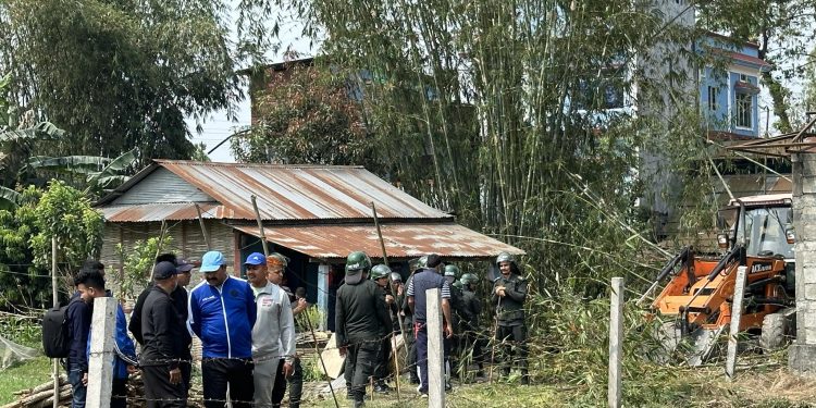
KATHMANDU: The Itahari Sub-Metropolitan City has embarked on a mission to demolish illegal constructions erected along riverbanks and floodplains.
Prompted by recurrent flooding incidents in Itahari, the sub-metropolitan city has mobilized bulldozers to clear encroached areas.
Mayor Hemkarna Poudel announced the initiative, commencing operations on Tuesday, with bulldozers initiating work from top area of the Tengra River in Itahari.
Accompanied by a bulldozer, Mayor Poudel personally oversaw the clearance of encroached land along the riverbanks. He emphasized that the demolition of illegal structures became imperative after repeated warnings were disregarded.
Mayor Poudel stressed the importance of reclaiming encroached land to mitigate flooding risks and ensure the safety of residents living in riverine settlements.
The sub-metropolitan city has initiated the removal of structures encroaching within a 6-meter radius from both sides of the Tengra River, Kheti River, and Sukumbari Paini, in compliance with existing regulations mandating a buffer zone along riverbanks.
Despite average rainfall during monsoon seasons, Itahari frequently experiences flooding, posing a constant threat to residents. The annual onset of heavy rains compounds these risks, triggering panic among riverbank inhabitants.
Mayor Poudel affirmed the sub-metropolitan city’s commitment to safeguarding riverine settlements from potential calamities, particularly during the upcoming winter season.
Wards 3, 4, 9, 10, 11, and 12 of Itahari bear the brunt of floods, with devastating consequences. In 2074, nine lives were claimed by the floodwaters, while four fatalities were recorded in the previous year. Moreover, extensive damage was inflicted upon agricultural crops and vital infrastructure.
Except for the years 2074 and 2078, the flood of 2043 surged to the levels of the Tengra River, inundating the lands of Ward Nos. 1, 4, and 8 of the former Itahari, submerging them under at least 10 feet of water.
Similarly, the flood of 2053 brought inundation to Itahari once more, with the soil covered up to two feet during that time.
In the 2040s, Itahari’s landscape was characterized by sparse population and extensive agricultural land use. Water channels and drains were strategically placed across the region to facilitate efficient drainage and minimize flood risks.
The residents of Itahari have been suffering from floods due to the fact that they have not made a long-term plan at the place where the flood enters Itahari.

